Denali National Park and Preserve
| Denali National Park and Preserve | |
|---|---|
|
IUCN category VI (protected area with sustainable use of natural resources)
|
|
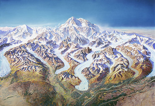
 Denali (Mount McKinley) is the tallest peak in North America
|
|

|
|
| Location | Denali Borough and Matanuska-Susitna Borough, Alaska, USA |
| Nearest city | Healy |
| Coordinates | 63°20′0″N 150°30′0″W / 63.33333°N 150.50000°WCoordinates: 63°20′0″N 150°30′0″W / 63.33333°N 150.50000°W |
| Area | 4,740,911 acres (19,185.79 km2) (park) and 1,304,242 acres (5,278.08 km2) (preserve) [1] |
| Established | February 26, 1917 |
| Visitors | 392,844 (in 2012)[2] |
| Governing body | National Park Service |
Denali National Park and Preserve is a national park and preserve located in Interior Alaska, centered around Denali (Mount McKinley), the highest mountain in North America. The park encompasses more than 6 million acres (24,500 km²), of which 4,724,735.16 acres (19,120 km²) are federally owned. The national preserve is 1,334,200 acres (5,430 km²), of which 1,304,132 acres (5,278 km²) are federally owned. On December 2, 1980, a 2,146,580 acre (8,687 km²) Denali Wilderness was established within the park. Denali's landscape is a mix of forest at the lowest elevations, including deciduous taiga. The preserve is also home to tundra at middle elevations, and glaciers, rock, and snow at the highest elevations. The longest glacier is the Kahiltna Glacier. Today, 400,000 people visit the park annually. They view wildlife, climb mountains, and backpack. Wintertime activities includes dog-sledding, cross-country skiing, and snowmachining.
Contents
Geography[edit source | edit]

Denali National Park and Preserve includes the central, highest portion of the Alaska Range, together with many of the glaciers and glacial valleys running southwards out of the range. To the north the park and preserve encompass the valleys of the McKinley, Toklat and Foraker Rivers, as well as the Kantishna and Wyoming Hills. The George Parks Highway runs along the eastern edge of the park, crossing the Alaska Range at the divide between the valleys of the Chulitna River and the Nenana River. The entrance to the park is about 11 miles (18 km) south of Healy. The Denali Visitor Center and the park headquarters are located just inside the entrance. The park road parallels the Alaska Range for 92 miles (148 km), ending at Kantishna. Preserve lands are located on the west side of the park, with one parcel encompassing areas of lakes in the Highpower Creek and Muddy River areas, and the second preserve area covering the southwest end of the high Alaska Range around Mount Dall. In contrast to the park, where hunting is prohibited or restricted to subsistence hunting by local residents, sport hunting is allowed in the preserve lands.[3]

Vehicle access[edit source | edit]

The park is serviced by a 91-mile (146 km) road from the George Parks Highway to the mining camp of Kantishna. It runs east to west, north of and roughly parallel to the imposing Alaska Range. Only a small fraction of the road is paved because permafrost and the freeze-thaw cycle would create a high cost for maintaining a paved road. The first 15 miles (24 km) of the road are available to private vehicles. Beyond this point, visitors must access the interior of the park through concessionary buses. Wonder Lake can be reached by a six-hour bus ride from the Wilderness Access Center. Eielson Visitor Center is located four hours into the park on the road.
Several fully narrated tours of the park are available, the most popular of which is the Tundra Wilderness Tour.[citation needed] The tours travel from the initial boreal forests through tundra to the Toklat River or Kantishna. A clear view of the mountain is possible about 20% of the time during the summer due to clouds.[citation needed] It is visible more often during the winter.[citation needed] Several portions of the road run alongside sheer cliffs that drop hundreds of feet at the edges. There are no guardrails. As a result of the danger involved, and because most of the gravel road is only one lane wide, drivers must be trained in procedures for navigating the sharp mountain curves, and yielding the right-of-way to opposing buses and park vehicles.
While the main park road goes straight through the middle of the Denali National Park Wilderness, the national preserve and portions of the park not designated wilderness are even more inaccessible. There are no roads extending out to the preserve areas, which are on the far west end of the park. The far north of the park, characterized by hills and rivers, is accessed by the Stampede Trail, a dirt road which stops at the park boundary. The rugged south portion of the park, characterized by large glacier-filled canyons, is accessed by Petersville Road, a dirt road that stops about 5 miles (8.0 km) outside the park. The mountains can be accessed most easily by air taxis that land on the glaciers.
Wilderness[edit source | edit]

The Denali Wilderness is a wilderness area in the Denali National Park and Preserve. It encompasses the high heart of the Alaska Range, including Denali. The Wilderness comprises about one-third of the national park.
Denali Wilderness covers the area formerly known as Mount McKinley National Park from 1917 until the park was expanded and renamed in 1980. It is 2,146,580 acres (8,687 km²) in area; the entire park is larger than the state of Massachusetts.[4]
Geology[edit source | edit]
Denali National Park and Preserve is located in the central area of the Alaska Range, a mountain chain extending 600 miles (970 km) across Alaska. Its best-known geologic feature is Mount McKinley, also known by its Athabascan name of Denali.[citation needed] Its elevation of 20,320 feet (6,190 m) makes it the highest mountain in North America. Its vertical relief (distance from base to peak) of 18,000 feet (5,500 m) is the highest of any mountain in the world. The mountain is still gaining about 1 millimetre (0.039 in) in height each year due to the continued convergence of the North American and Pacific Plates. The mountain is primarily made of granite, a hard rock that does not erode easily; this is why it has retained such a great height rather than being eroded.
There are three major rock provinces that run in east-west bands through the park. The oldest is in the north, and the younger ones in the south.[citation needed] The area is characterized by collision tectonics: over the past millions of years, exotic terranes in the Pacific Ocean have been moving toward the North American landmass and accreting, or attaching, to the area that now makes up Alaska.
The oldest rocks in the park are part of the Yukon-Tanana terrane. They originated from ocean sediments deposited between 400 million and 1 billion years ago. The original rocks have been affected by the processes of regional metamorphism, folding, and faulting to form rocks such as schist, quartzite, phyllite, slate, marble, and limestone.
The next oldest group of rocks is the Farewell terrane. It is composed of rocks from the Paleozoic era (250-500 million years old). The sediments that make up these rocks were deposited in a variety of marine environments, ranging from deep ocean basins to continental shelf areas. The abundant marine fossils are evidence that around 380 million years ago, this area had a warm, tropical climate.
The Pingston, McKinley, and Chulitna terranes are the next oldest; they were deposited in the Mesozoic era. The rock types include marble, chert, limestone, shale, and sandstone. There are intrusions of igneous rocks, such as gabbro, diabase, and diorite. Special features include pillow basalts, which are formed when molten lava flows into water and a hard outer crust forms, making a puffy, pillow shaped feature; as well as an ophiolite sequence, which is a distinct sequence of rocks indicating that a section of oceanic crust has been uplifted and thrust onto a continental area.

Some of the youngest rocks in the park include the Kahlitna terrane, which is a flysch sequence (a sedimentary rock sequence deposited in a marine environment during the early stages of mountain building) formed about 100 million years ago, during late Cretaceous time. Another rock sequence is the McKinley Intrusive Sequence, which includes Mount McKinley. The Cantwell Volcanics include basalt and rhyolite flows, as well as ash deposits. An example can be seen at Polychrome Pass in the park. [5]
Denali National Park and Preserve is located in an area of intense tectonic activity: the Pacific Plate is subducting under the North American plate, creating the Denali fault system, which is a right-lateral strike-slip fault over 720 miles (1,160 km) long. This is a part of the larger fault system which includes the famous San Andreas Fault of California. Over 600 earthquakes occur in the park each year, helping seismologists to understand this fault system. Most of these earthquakes are too small to be felt, although two large earthquakes did occur in 2002. On October 23, 2002 a magnitude 6.7 earthquake occurred in the park, and on November 3, 2002, a magnitude 7.9 earthquake occurred. These earthquakes did not cause a significant loss of life or property, since the area is very sparsely populated, but they did trigger thousands of landslides. [6]
Fossils[edit source | edit]
Denali is emerging as a site of interesting fossils, including footprints (ichnites) that when they were first publicly reported in May 2006, were credited with being the first evidence of prehistoric wading birds probing in mudflats for food during the Late Cretaceous Period. A footprint of a carnivorous theropod had previously been reported in the park.
Glaciers[edit source | edit]

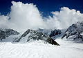
Glaciers cover about 16% of the 6 million acres of Denali National Park and Preserve. There are more extensive glaciers on the southeastern side of the range because more snow is dropped on this side from the moisture-bearing winds from the Gulf of Alaska. The 5 largest south-facing glaciers are Yetna (20 miles (32 km) long), Kahiltna (30 miles (48 km)), Tokositna (23 miles (37 km)), Ruth (31 miles (50 km)), and Eldrige (30 miles (48 km)).[5] The Ruth glacier is 3,800 feet (1,200 m) thick. [6] However, the largest glacier, Muldrow glacier (32 miles (51 km) long), is located on the north side. Nonetheless, the northern side has smaller and shorter glaciers overall. Muldrow glacier has "surged" twice in the last hundred years. Surging means that it has moved forward for a short time at a greatly increased rate of speed, due to a build-up of water between the bottom of the glacier and the bedrock channel floating on the ice (due to hydrostatic pressure).[5]
At the upper ends of Denali’s glaciers are steep-walled semicircular basins called cirques. Cirques form from freeze-thaw cycles of meltwater in the rocks above the glacier, and by glacial erosion and mass wasting occurring under the glacier. As cirques on the opposite sides of a ridge are cut deeper into the divide, they form a narrow, sharp, serrated ridge called an arête. As the arête wears away from glacial ice breaking it down, the low point between cirques is called a col (or if it is large, a pass). Cols are saddle-shaped depressions in the ridge between cirques. A spire-like sharp peak, called a horn, is formed when cirques cut back into a mountaintop from three or four sides.
Glaciers deposit rock fragments, but the most notable of the depositions are the erratics, which are large rock fragments carried some distance from the source, found on glacial terraces and ridge tops in many places throughout Denali. Headquarter erratics are made of granite and can be the size of a house. Some erratics (like those from the Yanert Valley) are located 30 miles (48 km) away from their original location.
Large amounts of rock debris are carried on, in, and beneath the ice as the glaciers move downslope. Lateral moraines are created as debris accumulates as low ridges of till that ride along the edge of the moving glaciers. When lateral moraines adjacent to each other join, they create medial moraines, which are also carried down on the surface of the moving ice.
Braided meltwater streams heavily loaded with rock debris continually shift and intertwine their channels over valley floors. Valley trains are built up as streams drop quantities of poorly sorted sediment. Valley trains are long, narrow accumulation of glacial outwash, confined by valley walls.
Kettles are formed when glacial retreat and melting is rapid, and blocks of ice are still buried under till. When the ice under the till melts, the till slumps in and forms depressions called kettles. When kettles fill with water, they are known as kettle lakes. The most famous kettle lake in Denali is Wonder Lake.[citation needed] Near Kantishna, it is the result of both glacial erosion and ice-block melting. It is about 4 miles (6.4 km) long and 280 feet (85 m) deep.
Permafrost[edit source | edit]
During the very cold Pleistocene climates, all of Denali was solidly frozen. In the northern areas of the range, it is very much still frozen due to continued cold temperatures. Permanently frozen ground is known as permafrost. In Denali, the permafrost is discontinuous, meaning due to difference in vegetation, temperatures, snow cover, hydrology, etc., not all of the ground is solidly frozen. The active layer (the layer that freezes and thaws seasonally) can be from 1 inch (25 mm) to 10 feet (3.0 m) thick. The permafrost layer below the active layer has been measured to be between 30 and 100 feet (9.1 and 30 m) deep depending on the location of measurement in the park. A stand of white spruce growing on a lower slope of Mount McKinley is called the Drunken Forest because of the oddly leaning trees which seem to look "drunk." This appearance is due to the sliding soil beneath them, due to the permafrost difference and freeze-thaw oscillations that occur due to differences in temperature, vegetation, and hydrology.
Shallow ponds in Denali are known as thaw lakes and cave-in lakes. They form where sunwarmed water has melted basins in the underlying permafrost. They deepen gradually in the summer months depending on the temperature variance. If the temperature is high enough, the thaw lakes and cave-in lakes will enlarge as their rims collapse.
Ice has 10 percent greater volume than water, so it continues to exert pressure on the ground. Thermal expansion and contraction can cause cracks to develop in the permafrost. During the thaw season in the freeze-thaw cycle, water gets into the cracks and forms veins of ice called ice wedges. Ice wedges enlarge with successive seasons of freezing and thawing. Some ice wedges that have been buried for centuries are revealed during excavations or landslides. [5]
History[edit source | edit]
Prehistory and protohistory[edit source | edit]
Human habitation in the Denali Region extends to more than 11,000 years before the present, with documented sites just outside park boundaries dated to more than 8,000 years before present. However, relatively few archaeological sites have been documented within the park boundaries, owing to the region's high elevation, with harsh winter conditions and scarce resources compared to lower elevations in the area. The oldest site within park boundaries is the Teklanika River site, dated to about 7130 BP. More than 84 archaeological sites have been documented within the park. The sites are typically characterized as hunting camps rather than settlements, and provide little cultural context. The presence of Athabaskan peoples in the region is dated to 1,500 - 1,000 years before present on linguistic and archaeological evidence, while researchers have proposed that Athabaskans may have inhabited the area for thousands of years before then. The principal groups in the park area in the last 500 years include the Koyukon, Tanana and Dena'ina people.[7]

Establishment of the park[edit source | edit]
The history of the park started when Charles Alexander Sheldon took an interest in the Dall sheep native to the region and became concerned that human encroachment might threaten the species. After his 1907-1908 visit, he petitioned the people of Alaska and Congress to create a preserve for the sheep. (His account of the visit was published posthumously as The Wilderness of Denali, ISBN 1-56833-152-5). The park was established as Mount McKinley National Park on February 26, 1917. However, only a portion of Mount McKinley (not even including the summit) was within the original park boundary. The park was designated an international biosphere reserve in 1976. A separate Denali National Monument was proclaimed by Jimmy Carter on December 1, 1978.
Naming controversy[edit source | edit]

The name of Mount McKinley National Park was subject to local criticism from the beginning of the park. The word "Denali" means "the high one" in the native Athabaskan language and refers to the mountain itself. The mountain was named after newly-elected US president William McKinley in 1897 by local prospector William A. Dickey.[citation needed] In 1980, Mount McKinley National Park was combined with Denali National Monument. At that time the Alaska Board of Geographic Names changed the name of the mountain back to "Denali," even though the U.S. Board of Geographic Names maintains "McKinley".[citation needed] Alaskans tend to use "Denali" and rely on context to distinguish between the park and the mountain.[citation needed]
Climate[edit source | edit]
Long winters are followed by short growing seasons. Eighty percent of the bird population returns after cold months, raising their young. Most mammals and other wildlife in the park spend the brief summer months preparing for winter and raising their young.
Summers are usually cool and damp, but temperatures in the 70s are not rare. The weather is so unpredictable that there have even been instances of snow in August.
The north and south side of the Alaskan Range have a completely different climate. The Gulf of Alaska carries moisture to the south side, but the mountains block water to the north side. This brings a drier climate and huge temperature fluctuations to the north. The south has transitional maritime continental climates, with moister, cooler summers and warmer winters.
Ecology[edit source | edit]
The Alaska Range is a mountainous expanse running through the entire park, strongly influencing the park's ecosystems. Vegetation in the park depends on the altitude. The treeline is at 2,500 feet (760 m), causing most of the park to be a vast expanse of tundra. In the lowland areas of the park, such as the western sections surrounding Wonder Lake, spruces and willows dominate the forest. Most trees and shrubs do not reach full size, due to unfavorable climate and thin soils. There are three types of forest in the park: from lowest to highest, they are low brush bog, bottomland spruce-poplar forest, upland spruce-hardwood forest. The forest grows in a mosaic, due to periodic fires.
In the tundra of the park, layers of topsoil collect on rotten fragmented rock moved by thousands of years of glacial activity. Mosses, ferns, grasses, and fungi grow on the topsoil. In areas of muskeg, tussocks form and may collect algae. The term 'muskeg' includes spongy waterlogged tussocks as well as deep pools of water covered by solid-looking moss. Wild blueberries and soap berries thrive in the tundra and provide the bears of Denali with the main part of their diet.
-
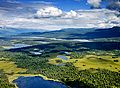
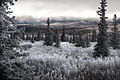
thumb|Alpine forest and lakes in Denali
-
Sunrise over mountains in Denali
-
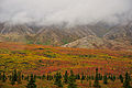
Colourful vegetation
-
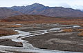
The Park near Savage River
-
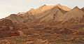
Alaska Range
-
Ruth Gorge


Over 450 species of flowering plants fill the park and can be viewed in bloom throughout summer. Images of goldenrod, fireweed, lupine, bluebell, and gentian filling the valleys of Denali are often used on postcards and in artwork.
Denali is home to a variety of Alaskan birds and mammals, including a grizzly bears and black bears. Herds of caribou roam throughout the park. Dall sheep are often seen on mountainsides, and moose feed on the aquatic plants of the small lakes and swamps. Despite human impact on the area,[clarification needed] Denali accommodates gray wolf dens, both historic and active. Smaller animals, such as hoary marmots, arctic ground squirrels, beavers, pikas, and snowshoe hares are seen in abundance. Foxes, martens, lynx, wolverines also inhabit the park, but are more rarely seen due to their elusive natures.
-
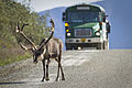
A caribou on a road in Denali National Park
-

Grizzly bear in Denali
-
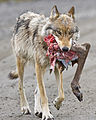
A wolf with the hindquarter of a caribou
-
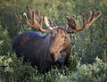
Bull moose in Denali
-
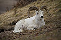
Dall sheep
-
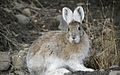
Snowshoe hare


Many migratory species reside in the park during late spring and summer. There are waxwings, Arctic Warblers, pine grosbeaks, and wheatears, as well as Ptarmigan and the majestic tundra swan. Predatory birds include a variety of hawks, owls, and the gyrfalcon, as well as the abundant but striking golden eagle.
Ten species of fish, including trout, salmon, and arctic grayling, share the waters of the park. Because many of the rivers and lakes of Denali are fed by glaciers, glacial silt and cold temperatures slow the metabolism of the fish, preventing them from reaching normal sizes.[citation needed] A single amphibious species, the wood frog, also lives among the lakes of the park.
Denali park rangers maintain a constant effort to keep the wildlife wild by limiting the interaction between humans and park animals. However, the number of wild bears necessitates their wearing collars to track movements.[clarification needed] Feeding any animal is strictly forbidden, as it may cause adverse effects on the feeding habits of the creature. Visitors are encouraged to view animals from safe distances. Despite the large concentration of bears in the park, efforts by rangers to educate backpackers and visitors about preventive measures and BRFCs have greatly reduced the number of dangerous encounters.[citation needed] In August 2012 the park experienced its first ever fatal bear attack when a lone hiker apparently startled a large male grizzly while photographing it. Analysis of the scene and the hiker's camera strongly suggest he violated park regulations regarding backcountry bear encounters, which all permit holders are made aware of. [8] Certain areas of the park are often closed due to uncommon wildlife activity, such as denning areas of wolves and bears or recent kill sites.
See also[edit source | edit]
References[edit source | edit]
- ^ "Listing of acreage as of December 31, 2012". Land Resource Division, National Park Service. Retrieved 2013-03-27.
- ^ "NPS Annual Recreation Visits Report". National Park Service. Retrieved 2013-03-25.
- ^ "Map of Denali National Park and Preserve". Denali National Park and Preserve. National Park Service. Retrieved 25 March 2013.
- ^ Wilderness.net – Denali Wilderness
- ^ a b c d Harris, A.G., Tuttle, E., Tuttle S.D. Geology of National Parks. 6th ed. Kendall/Hunt Publishing Company 2004.
- ^ a b National Park Service: Denali National Park and Preserve. Denali Rocks! The Geology of Denali National Park and Preserve: A Curriculum Guide for Grades 6-8. 2011.
- ^ Norris, Vol. 1, pp. 2-3
- ^ Demer, Lisa, Hiker's camera offers clues to bear attack Anchorage Daily News, 8/27/12
Bibliography[edit source | edit]
- Brown, William E. (1991) A History of the Denali-Mount McKinley Region, Alaska, National Park Service
- Collier, Michael (2007), The Geology of Denali National Park and Preserve. Alaska Geographic. ISBN 978-0-930931-04-9
- Harris, Ann G.; Tuttle, Esther; Tuttle, Sherwood D. (2004). Geology of the National Parks, 6th ed. Kendall/Hunt. ISBN 978-0-7872-9971-2
- Murie, Adolph (1961), A Naturalist in Alaska. Devin-Adair.
- Murie, Adolph (1981), The Grizzlies of Mount McKinley, National Park Service
- Murie, Adolph (1944), The Wolves of Mount McKinley, Fauna of the National Parks of the United States Series No. 5, National Park Service
- Norris, Frank (2006), Crown Jewel of the North:An Administrative History of Denali National Park and Preserve, Volume 1, National Park Service (10 MB download)
- Norris, Frank (2006), Crown Jewel of the North:An Administrative History of Denali National Park and Preserve, Volume 2, National Park Service (80 MB download)
- Scoggins, Dow (2004), Discovering Denali: A Complete Reference Guide to Denali National Park and Mount McKinley, Alaska. iUniverse Star. ISBN 0-595-29737-4
- Sheldon, Charles (1930), The Wilderness of Denali. Derrydale Press (reprint), ISBN 978-1568331522
- Waits, Ike (2010), Denali National Park, Alaska: Guide to Hiking, Photography and Camping. Wild Rose Guidebooks. ISBN 978-0-9677327-2-5
External links[edit source | edit]
| Wikimedia Commons has media related to: Denali National Park |
| Wikivoyage has travel information related to: Denali National Park |
- Denali National Park & Preserve National Park Service site
- Denali National Park and Preserve at the National Park Service Alaska Regional Office
- NPS Education packet

|
|||||
|
||||||||||||||||||||||||||||||||||||||||||