| |
American
troops landed on Amchitka to establish The Naval Air Facility on 24
February 1943. To make
way for
them, the U.S. forcibly evacuated the local Aleuts and interned them
thousands
of miles away. Near the end of World War II, Amchitka Island was an
advance
location for planning the invasion of the northern islands of Japan
(the
Kuriles). The south-eastern portion of the island had buildings to
house an infantry
division of about 13,000. At this time Amchitka had three runways.
"Fox" was shortest and closest to what is now Constantine Harbor.
"Charlie" and "Baker" were longer, and with "Charlie" at 10,000
feet in length, it was at that time the world's longest runway. By
1949-1950,
the Air Force presence on Amchitka had dropped to about 40.
evacuated the local Aleuts and interned them
thousands
of miles away. Near the end of World War II, Amchitka Island was an
advance
location for planning the invasion of the northern islands of Japan
(the
Kuriles). The south-eastern portion of the island had buildings to
house an infantry
division of about 13,000. At this time Amchitka had three runways.
"Fox" was shortest and closest to what is now Constantine Harbor.
"Charlie" and "Baker" were longer, and with "Charlie" at 10,000
feet in length, it was at that time the world's longest runway. By
1949-1950,
the Air Force presence on Amchitka had dropped to about 40.
During the postwar period, Amchitka Island was a military outpost to provide a radio range station and alternate landing site for aircraft flying the Aleutian Islands. It was also a weather monitoring site for Russian weather reports where six full time radio operators monitored Russian weather broadcasts.
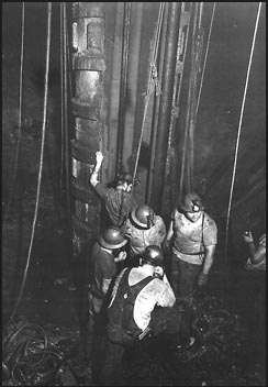
Between 1950 and 1961 Amchitka Island was used in the Distant Early Warning network. Between 1965 and 1971 Amchitka was the site for underground nuclear testing. Between 1986 and 1993 it was used for construction and operation of the Relocatable Over the Horizon Radar.
Amchitka today is uninhabited, but residents of villages on other islands sometimes hunt for marine mammals or fish near it. Seals, fish and other marine life migrate among the islands. Presently, Amchitka Island is a National Refuge.
 after
a nearby
magnitude-8.7
earthquake
to determine whether monitoring techniques could differentiate between
natural
seismicity and nuclear explosions. Milrow was a seismic calibration
test
detonated at a depth of 1,220 meters with an approximate one megaton
yield.
Cannikin, a test of the proposed Spartan missile warhead, was detonated
at a
depth of 1,790 meters, with a yield slightly less than five megatons.
after
a nearby
magnitude-8.7
earthquake
to determine whether monitoring techniques could differentiate between
natural
seismicity and nuclear explosions. Milrow was a seismic calibration
test
detonated at a depth of 1,220 meters with an approximate one megaton
yield.
Cannikin, a test of the proposed Spartan missile warhead, was detonated
at a
depth of 1,790 meters, with a yield slightly less than five megatons.
Data from the Nevada Test Site shows what happens following underground nuclear tests. Upon detonation, nearby rock vaporizes, or melts into a puddle of magma on the floor of the explosion cavity. Part of this magma turns to glass. The roof of the cavity then collapses in a second wave of fracturing forming a chimney to the surface. The shock from the detonation causes extensive fracturing well beyond the blast site.
Most radionuclides remain within the magma-turned-glass cavity. Some radionuclides move up with the silicate vapor from the vaporized rock and then settle within the collapsed chimney. Today, one of the key areas of investigation for Amchitka is whether groundwater percolating through the areas may carry radioactive materials towards the ocean. This is the focus of the research described on these web pages.
Of the
three
Amchitka tests, only Cannikin produced any surface expression that is
obvious
today. The Cannikin explosion extended out through existing geological
faults
and drove from them groundwater which some observers reported seeing
shoot up
20 feet from the land surface. Within two days of the detonation, a
crater
formed almost 2 km wide and 12 m deep.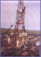
Near ground zero Cannikin was measured at magnitude-6.8 and the largest subsidence event that followed was 4.9. Subsidence and faulting dammed nearby White Alice Creek, which then filled portions of the explosion cavity and collapsed chimney, forming Cannikin Lake. There were individual fractures up to 2 km in length with as much as 6 m of vertical displacement. At the Bering Coast there was about a meter of uplift.
The Army Corps of Engineers, the Fish and Wildlife Service, the Department of Defense, and the Department of Energy have all conducted activities on Amchitka. The Environmental Protection Agency is reviewing Amchitka’s Hazard Ranking Score to determine whether Amchitka should be placed on to the National Priorities List as defined by the Comprehensive Environmental Response, Compensation, and Liability Act.